This blog, which was originally published on LinkedIn, was written by Victoria Ramsey, Senior Climate Scientist at the Met Office. She is co-investigator of the UKCR project Prototype development: Meeting Urban User Needs.
As Met Office has been showcasing the work we have done in cities, I thought it would be a nice opportunity to reflect on our work exploring heat risks in UK cities.
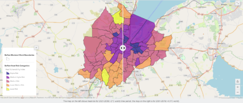
When it comes to emergency planning, a lot of local authorities have plans for cold and flooding events but are increasingly being forced to think more about how heat related impacts will affect local communities. A project of the UK Climate Resilience programme, supported by the UK Government’s Strategic Priorities Fund and led by the Met Office, has developed an urban heat climate service pilot for Belfast designed to help city stakeholders use climate projections in decision-making contexts. The pilot includes a set of fact sheets and a heat vulnerability story map exploring heat risks within the city.
Urban heat climate services can support cities in becoming more resilient to extreme heat by informing adaption actions, such as retrofitting buildings to shade their windows or by increasing green spaces which can provide cool oases within the city. Councils can also make contingency plans to protect residents whenever heatwaves occur.
Walking Workshop
In August 2022, Alan Kennedy-Asser, Climate Northern Ireland’s embedded researcher from the University of Bristol, along with the Met Office Urban Climate Services team organised a ‘Walking Workshop’ through the city of Belfast to explore the prototype urban heat climate service and to understand how it may be used in decision making contexts. Attendees included key city stakeholders from health, built environment and Belfast City Council’s climate team and Healthy Cities Network.
The session started off with a walk through the city and followed a route through wards at lower and higher risk of climate impacts from heat. Several stops were planned to examine the presence of green and blue spaces, building types, deprivation and socio-economic factors that when combined with the climate data are used to develop a heat vulnerability index. There was also a deep dive into the data for each ward that we walked through in terms of levels of hazard exposure, sensitivity and adaptive capacity.

Discussion Workshop
The walk was followed by a workshop where participants reflected on the recent heatwave and considered high risk groups and assets which could be targeted for change.
The recent heatwave provided an excellent example of the importance of understanding the risks associated with excessive heat and how adaptation measures can be considered. For example, whilst many reflected on the positive opportunity to spend time outdoors, there was concern for elderly relatives and other vulnerable groups. It was acknowledged that improved availability, accessibility and usability of green spaces and better street design could reduce hard surfaces, provide more shade, reduce noise and have wider health benefits. They also discussed how new housing developments should consider shading, SuDS (Sustainable Urban Drainage Systems) and natural ventilation.
Following these discussions, participants were given a scenario for health and built environment separately and asked to identify impacts and considerations before, during and after a heatwave event, as well as for longer term planning and to think about how the information from the heat service could be used within these processes, as well as any gaps in information.
There were some fruitful discussions around use of the information for communicating the impacts of heat both in the short and longer terms, informing strategic plans such as the city’s climate change risk assessment, Local Development Plan, and heatwave planning, as well as the prioritisation of work in different areas and to align with other projects within the city.

Having not undertaken a walking workshop previously, it was great to hear from the participants that they found this very useful to improve their understanding of heat risk by putting the information into context. The discussion workshop then aided understanding of how to use data products in decision-making and helped identify immediate uses for heat information.

